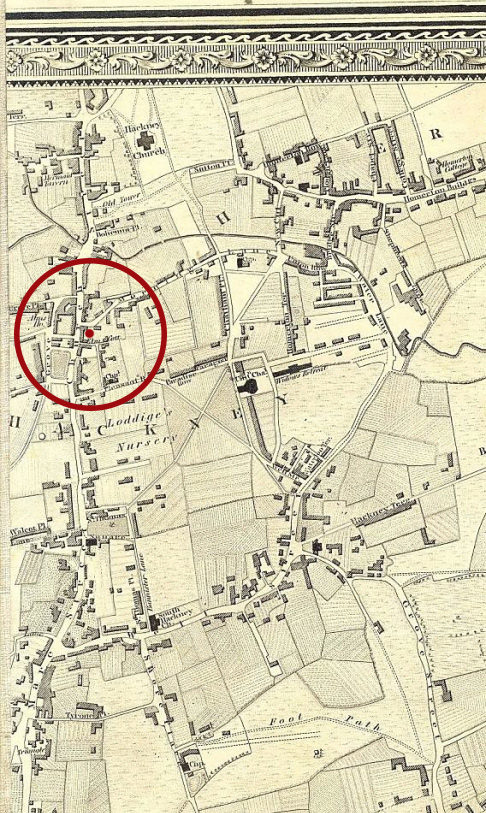
Fields of 1741

Another little map, this one quite hard to see but part of the  “exact survey of the cities of London and Westminster, the Borough of Southwark, with the country near ten miles round.” done by John Rocque in 1741. This is the earliest known map to feature Hackney as far as the council bods are concerned.

You can find the original at Royal Museums Greenwich. Irritatingly, the image they have is low res and cut at an unfortunate point, presumably so they can sell scans of it off as prints. A stitched-together greyscale version of the whole thing is available on Wikipedia and a gorgeous tweaked version of his City-only map is available here.

Valette1741.jpg

Immortalised in acrylic and ink

VALETTE_HOUSE

Missed this when it first exhibited in 2012, but local artist Frank Laws did a detailed piece on what looks like the southern wing of Valette House done from the Wetherspoons balcony? More detailed views are available at his website.

Working mostly in ink, with some watercolour and acrylic, he has photographed the daily progress of building work taking place at Valette House, off Mare Street. This served as the basis for a large painting which will form the centerpiece of his show next month.

Previous exhibitions at the V&A, Print House Gallery in Dalston, Somerset House and Lazarides Gallery have also shown Laws’s meticulously detailed paintings of inner-city dwellings.

He wonders if working as a labourer when he first moved to London (from a village called Spooner Row – “I think they used to make spoons there”) made him more perceptive of the buildings surrounding him and the way they were constructed.

But he is also interested in the history of East London’s social housing. “East London was one of the first areas in the city to undergo slum clearance and redevelopment,” Laws explains, “I find the work, planning and care that went into those projects really reflects the idea of making things better for people.”

He hopes to relay his admiration for the efforts that were made to aid people during difficult times through his paintings, as well revealing the aspects of the estates that people often overlook: “I like the everyday feeling about estates, the things people don’t notice.”

~ From Annie Ridout’s 2012 interview

Fun with maps

Below is a map from 1827. The whole area at the time was fields and villages, and Mare Street itself was lined with the expensive abodes of former traders. I’ve marked an approximate spot for Valette on it.

hackney-in-greenwoods-1827-map

And here’s one from 1868. In less than a lifetime, the area had become an urban outrider of the city proper with large buildings, a road network, schools and multitudinous alms houses. The speed of growth must have been mindblowing to the rural population who were seeing this grow up around them. At this time it was still technically part of Middlesex but was fast being swallowed, and Hackney was formally annexed by London in 1899.

Valette-1868

One noteable thing about the second map is that Jerusalem Square, later replaced by Valette House and Street, is characterised as being part of a slum, later being knocked down to widen the road. At the time a large rise in population saw lots of people being pushed into these areas, where they jerry-built housing and upset the well-to-do types on Mare Street.

This is well illustrated because handily, just five years before demolition work started in Valette Street, Charles Booth finished his infamous map of poverty in London (searchable here). Blue represents a high poverty level, red for the middle class.

mrsid2jpeg

Enclosed slum squares, very densely populated (around 500 people were squeezed into the space when it was earmarked for demolition) were known as rookeries at the time, and constantly bashed for their alleged lawlessness. So Valette, along with being social housing with proper sanitation, appears to have been part of an attempt to impose some order on those unruly poor folk.

On the site of old Jerusalem

Valette House is one of the oldest public housing projects in Hackney, built as part of a major works by London County Council in 1904-6. Along with Darcy House (just off London Fields) it offered 120 dwellings for people relocated from Mare Street after it was widened and the local slum knocked down.

Valette Street was originally part of Jerusalem Square. The names are both redolent of Hackney’s Crusader-owned background, as the parish was mostly a Knights Templar holding back in the 13th century before being handed over to the Order of St. John of Jerusalem (also known as the Knights Hospitaller) after the Templars were disbanded in 1312.

This almost certainly explains the origin of the name Valette Street, and of Valette House. Jean Parisot de Valette (1495-1568) was one of the most famous members of the Hospitallers, known as ” the scourge of Africa and Asia, and the shield of Europe” for his role in repeatedly routing Ottoman forces, particularly during the siege of Malta – he went on to help found the island’s capital, Valetta.

Church_of_St_John-at-HackneyThe Hospitallers lost control of Hackney to the Crown during the Dissolution of the Monasteries (1536-41) but seem to have retained a place in the naming traditions of the parish ever since.

The Church of St John-at-Hackney, built in 1792 long after the Hospitallers were dumped, directly references the old associations.